
Svalbard: an island hiding in the snow
I’m not a geography expert, but I do like looking at maps. So imagine my surprise when I suddenly discover a large European island that I’ve never seen before.
Huh? Where did that come from?
It doesn’t generally appear on maps of Europe: it’s not on this one…
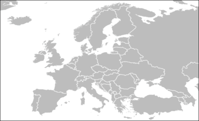
So what is it, and where is it?
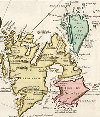
Well, it’s called Svalbard, and it’s made up of three islands, the largest one of which is Europe’s fifth largest island. So why don’t we see it on the other maps?
Simple: it’s too far up. It’s gone off the top of the map. The country of Norway extends into the Arctic Circle (at 66° 33′ North of the equator), with the mainland part of Norway extending to around 72° North. The Svalbard’s main island, Spitzbergen, starts at around 76° 30′ North. The most southerly point of the island is therefore 10° inside the Arctic Circle. It’s really quite Northern.
Svalbard contains the northernmost instance of several institutions - including the world’s northernmost school, church, hospital, bank, newspaper, commercial airport, movie theater and in-door swimming pool.Wikipedia: Svalbard
It was also a setting for much of Phillip Pullman’s books, but as I’ve not read them, I wouldn’t have known that. Spitzbergen, the largest island, has the Svalbard Global Seed Vault — which I have heard of (only I didn’t know where Spitzbergen was — which contains preserved copies of a wide variety of plant seeds as ‘insurance’ against major disasters.
Svalbard is part of Norway, but under the Svalbard treaty of 1925, anyone who is a member of one of the countries signing that treaty has an — if I am understanding this correctly — equal right to live, work, and exploit mineral resources there. As Britain was one of them, I’d almost be tempted to move, only I think it might be a little cold.
Only I reckon I’ve worked out how come I’ve never noticed before. I think it’s only because of the reduction in the Arctic sea ice that I’ve realised it actually was an island, rather than just ‘the bottom bit of the sea ice’.
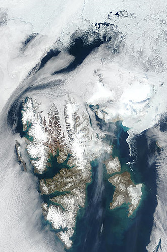
Take a look at this photo from NASA Visible Earth. This was taken in May 2002 (i.e. after the sea ice has started to melt a little). You can see why at a quick glance — particularly a glance taken when the sea ice is at its furthest extent — you might not realise that there was an island there at all, considering it simply the extent of the polar ice cap.
At least, that’s my story, and I’m sticking to it.
You might well wonder, ‘why the interest in an obscure part of Norway with only about 2400 inhabitants’? And the answer is I don’t really know. I was surprised to discover the island in the first place — I actually came to notice it because of the interactive Firefox Download Day 2008 Map, sadly showing that no-one on Svalbard downloaded Firefox on that day.
And for some reason when I was looking at an atlas with my four-year old, it caught my eye again, and it really caught my imagination — the idea that I could go and move there if I wanted to (although I don’t, unless they tow it south a bit first) — the idea of the seed bank, and, well, basically the idea that the world has had this great big island in it the whole time that I’d never noticed or known about until this year.
It even had Norway’s biggest earthquake in modern times earlier this year — 6.2 on the Richter scale — without the rest of the world seemingly noticing; it had three English settlements on it in the 17th Century that I’d never heard about either…
…it’s like some kind of ‘ghost’ island; because it’s so far North, and so sparsely inhabited (if it had a population density equivalent to England, it would have around 25 million inhabitants, instead of around 2,400), it’s almost like it doesn’t exist. And I think that is why it catches my imagination.
 Hello. I am
You missed University - the world’s northernmost university (my daughter spent some time there). Check out the webcams around Svalbard - mostly in Longyearbyen, the main settlement. Also, as I understand it, Svalbard is never heavily bound by sea ice as it is in the path of a warm current which runs up the European coast from Africa. Sadly, this is one of the things that researchers on the archipelago are looking into - the weakening of this current, due to the combined effects of global warming. If the current falters, changes direction or stops, it threatens Western Europe with a dramatic cooling. Fascinating place though - there are many photos on flickr under tags like svalbard, spitsbergen, longyearbyen, barentsburg.
It’s also interesting to note that it might be the saving of plantkind, well sort of. The Norwegian government recently opened a backup seed bank there dig into the side of a mountain near Longyeatbyen to store seeds from around the globe. Lets just hope the polar bears don’t break in and eat them all…
Peek at the Wikipedia entry for more details